Summary of power transmission and distribution of geographic information system GIS operation and management
电力输变电配电地理信息系统GIS运行管理概述
Summary of power transmission and distribution of geographic information system GIS operation and management
Power transmission and distribution of geographic information system is one of the core business to strengthen the operation and management of electric power enterprise assets, the use of geographic information and distribution business management facilities, implementation of software system for comprehensive function of mutual operation, query, analysis etc.. Through electronic map query substation, transmission, and distribution equipment with technology, spatial data by using the system, and also with the organic integration of production management, power marketing, remote meter reading system, realize the data sharing; at the same time using the GIS spatial data search technology, realize the calculation and equipment inspection work of theoretical line loss; developed in high, medium voltage power network planning, engineering and technical scheme, plays the auxiliary design ability.
In order to guarantee the normal operation of the system can be formulated for the management requirements in the company.
One, the system use the internal network to realize software real-time data sharing database operation, opposite, each terminal can be according to customer access to relevant content, login server IP: name:
Two the system maintenance, network operation by the information center is responsible for scheduling, in accordance with the network security requirements, operation and maintenance of the server regularly carry out inspection, quarterly report to production department system operation condition of health.
Three, the production department is the management unit of the application of the system, to guide the inspection appraisal work departments responsible for running the function and process of the system.
Four, equipment operation management unit requirements related to personnel who are familiar with the application of the system, using the method of operation and maintenance personnel can master the inspection instrument, GPS locator, the inspection content, unified by the monitor or technician input system.
Five, equipment modification and business expansion changes are required to work, in accordance with the company's production equipment change order process for approval, by the production supervisor assigned permissions strictly do change: account in actual, graphics and in line with the actual situation, the operation mode and actual.
Introduction to spatial electric power geographic information system of 2D GIS
Power GIS product solution goal is to GIS mode on power equipment, drawings, grid information management, providing intuitive, accurate spatial data support for network management, improve the management level of safety production in electric power enterprise. By means of electric energy data acquisition system, can improve the marketing management level in the digital grid based simulation of reality, so that enterprises can better grasp of market operation data of electric power enterprises, fully understand the market tension power supply from enterprises and supply pressure, which can better grasp of market. With the help of customer service system, the real-time data of system, fault repair, blackout notice, electricity query services such as management more convenient, fast, intuitive. Through the platform of power spatial information service of GIS can improve enterprise image of service, improve the quality of service management level. Change the past power enterprise information "incomplete, inconsistent, not timely, not correct" phenomenon, can meet the requirements of the electric power enterprise modernization "safe, reliable, high quality, high efficient, economic operation".
2 system features
Digital power grid spatial data model 2.1 construction of a full range of
Through the power network itself has the characteristics of network connectivity and traceability of rapidly established a grid simulation model structure, grid model is established with the charged topological relation, can simulate the real operation state of power grid.
After years of accumulation of the company GIS products, has formed a set of complete development of functional component library -- "GIS component library". Provincial grid companies of all kinds of complicated topological relationship of structure by using the "functional component of GIS component library" can be subordinate to the national grid, China Southern power grid transmission provides the basic platform to build grid model change with the integration of the.
Fig. the full range of grid spatial data model
2.2 to improve the business circulation mechanism driving rolling data update
Company development experience in the power industry, summarizes the business needs of the accumulation of typical application scenarios. According to the management mode of different power enterprises to link organically connected with processing all kinds of business GIS business application. The establishment of rolling data update mechanism, the dynamic GIS data up and running, with business demand driven data timely update GIS.
2.3 rich AM/GIS function, drawing management mode reformation of electric power enterprises
According to the actual distribution grid lines, extraction, generating station a diagram, layout, feeder graph (Dan Xiantu), a diagram of the whole network, the whole network backbone graph (electrical system diagram), cable, line sequence diagram, electric power communication, special regional map (thematic map crossing diagram, polluted area map, diagram, graph, icing wind micro meteorological area).
Automatic generation of business of thematic map is the function of the GIS backbone, substituted AutoCAD drawings complete with GIS system business project drawings, change GIS and CAD two sets of drawings of the coexistence of drawings management mode transformation.
3 business scope
Construction of 3.1 GIS substation and distribution integrated grid supporting platform based on
Construction of GIS substation and distribution integrated grid supporting platform based on, through the GIS technology, component technology, WEB technology, data warehouse technology, CASE technology, and existing IT systems (such as MIS, OA, ERP) are integrated to achieve enterprise facilities resources, human resources, work process, customer relationship comprehensive management, the realization enterprise economic, social the maximum benefit.
Fig. network topology
3.2 construction of the GIS business integration management of power enterprises based on
Power based on the GIS model, the maintenance of power grid planning and design, from run to, build a mutual independence and mutual collaboration and resource sharing of power enterprise business integration platform. Change the past power enterprise information "is not comprehensive
输变电配电地理信息系统是加强电力企业资产的运营管理核心业务之一,地理信息与配电业务管理配套使用,实现相互操作、查询、分析等综合功能的软件系统。可以利用该系统通过电子地图查询变电、输电、配电设备详细技术、空间资料,还可与生产管理、用电营销、远程抄表等系统有机融合,实现数据共享;同时运用GIS空间数据搜索技术,实现理论线损的计算和设备巡检工作;在高、中压电网规划、工程技术方案制定,都起到辅助设计的能力。
为了能够保证该系统在公司范围能正常运行特制定本管理要求。
一、本系统利用内部网实现软件数据实时共享,数据库对立运行,各终端客户均可按照权限查阅相关内容,登陆服务器IP: 户名:
二、本系统网络的运行维护由调度所信息中心负责,按照网络安全要求,对服务器定期开展运行维护检查,并按季度向生产部报告系统运行健康情况。
三、生产部是该系统应用的管理单位,部门主管负责该系统运行功能和流程环节的指导检查考核工作。
四、设备运行管理单位要求相关人员熟悉该系统的应用,运行维护人员能掌握巡检仪、GPS定位仪等的使用方法,巡检内容统一由班长或技术员输入系统。
五、设备改造及业扩等变更工作,均需按照公司生产设备变更单流程申请报批后,由生产部主管下达权限后变更严格做到:台账于实际相符、图形与实际相符、运行方式与实际相符。
二维空间电力地理信息系统GIS简介
电力GIS产品解决方案的目标就是以GIS方式对电网设备、图纸、电网信息进行综合管理,为电网管理提供直观、准确的空间数据支持,提高电力企业安全生产管理水平。借助于电能量采集系统数据,可以在模拟现实的数字电网基础上提高营销管理水平,可以使企业更好地全面掌握电力企业市场运营数据,充分了解供电的市场张力和来自企业供电的压力,从而能够更好地把握市场。借助于客服系统、实时系统数据,对故障报修、停电预告、电费查询等方面服务管理更加方便、快捷、直观。通过GIS的电力空间信息服务平台可以全面提升企业服务形象,提高优质服务管理水平。改变过去电力企业信息“不全面、不一致、不及时、不正确”现象,满足电力企业“安全、可靠、优质、高效、经济运行”的现代化要求。
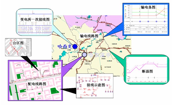
2系统特点
2.1构建全方位的数字化电网空间数据模型
通过电力网本身具有的联通性与可溯性的网络特点快速建立起仿真的电网模型结构,建立的电网模型具有带电拓扑关系,可以模拟电网的真实运行状态。
经过多年的积累公司的GIS产品,形成了一套完整开发功能组件库――“GIS组件库”。 利用“GIS组件库”的功能构件可以为国家电网、南方电网下属的网省公司各种繁杂结构拓扑关系的输变配一体化的电网模型建立提供基础平台。
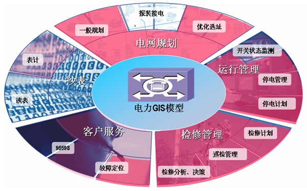
图 全方位电网空间数据模型
2.2完善的业务流转机制驱动数据滚动更新
公司在电力行业开发经验,总结业务需求积累典型应用场景。根据不同电力企业管理模式把GIS业务应用中各种业务处理环节有机的连接在一起。建立数据滚动更新机制,将GIS数据动态运转起来,以业务需求驱动GIS数据及时更新。
2.3丰富的AM/GIS功能,改造电力企业图纸管理模式
根据电网线路的实际分布情况,抽取、生成厂站一次结线图、平面布置图、馈线图(单线图)、全网一次结线图、全网主干图(电系图)、电缆截面图、线路相序图、电力通信专题图、特殊区域图(交叉跨越图、污区图、防风图、覆冰图、微气象区等)。
自动生成业务专题图的功能是GIS脊梁,以GIS系统业务专题图纸彻底取代AutoCAD图纸,改变GIS和CAD两套图纸并存的现象,改造图纸管理模式。
3业务范围
3.1基于GIS构建输变配电一体化电网支撑平台
基于GIS构建输变配电一体化电网支撑平台,通过GIS技术、组件技术、WEB技术、数据仓库技术、CASE技术,与已有IT系统(如MIS、OA、ERP)进行集成,实现企业设施资源、人力资源、工作流程、客户关系综合管理,实现企业经济、社会效益最大化。
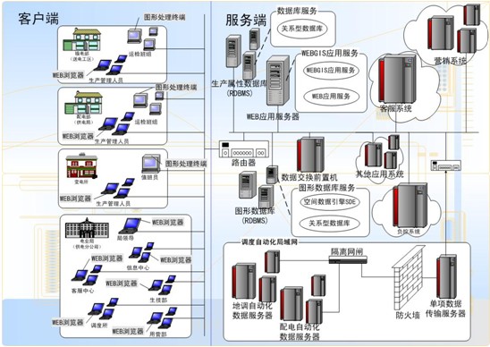
图 网络拓扑图
3.2基于GIS构建电力企业一体化业务管理
基于电力GIS模型,从电网规划、设计、运行到维护,构建一个既相互独立、又相互协作、资源共享的电力企业一体化业务平台。改变过去电力企业信息“不全面、不一致、不及时、不正确”现象,满足电力企业“安全、可靠、优质、高效、经济运行”的现代化要求。
三维空间电力地理信息系统GIS简介
基于三维的电力GIS系统才能让人们更直观、形象地认识百种现象,解决千种问题,从而切实提高工程效率和管理水平。为了保证国家电网的建设、维护及突发事件的应急处理。本系统最大限度地确保电网安全稳定运行和电力供应。能够在二维三维层面使用GIS技术手段对电网基本信息、实时运行信息、应急指挥信息进行展示的B/S图形化平台。
三维电网系统包括三维数字地形模型、高分辨率遥感影像数据、三维电力设施与设备模型的三维仿真场景,实现了对电网设备、电网建设区域的三维可视化仿真,并同时允许用户在三维场景中交互式的完成场景浏览、漫游、定位等操作,以全方位、直观化地了解电力网建设情况与电网所在区域环境。
功能简介
三维平台支持电力行业的特殊功能开发。例如在电力行业中较为常见的地上电力杆塔管理,地下电缆槽坑道管理等。
1. 支持加载大批量精细模型
平台支持加载大批量的高精度模型,完整展现模型中原有的各个细节。可以通过第一人称或第三人称视角的方式360°的浏览模型。当加载数千个电力杆塔模型后系统运行速度平稳。并且支持调整模型的缩放比例,位置等操作。
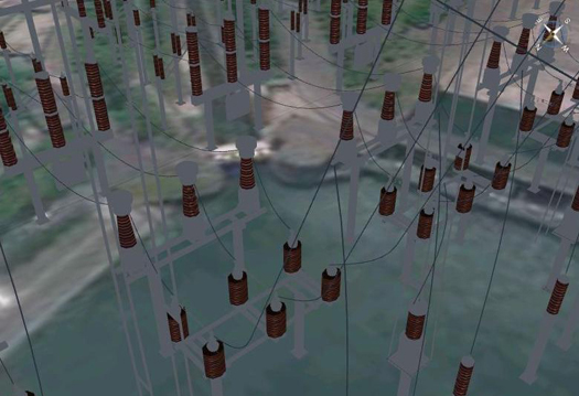
如加载某个复杂的变电站模型(局部)
2. 支持生成带有下垂效果的电缆线
平台支持按照相应规则自动连接电力杆塔之间的电缆线。同时能够按照真实情况绘制出电缆线的下垂效果。
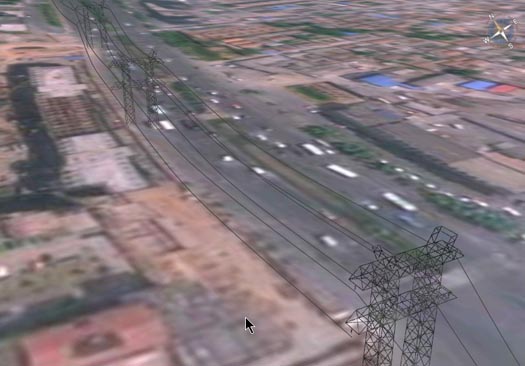
绘制带有下垂效果的电缆线
3. 更改电塔模型后自动重新生成电缆线连接
当更改一条电力线中的某个杆塔时,系统能够自动修改电缆线的连接方式
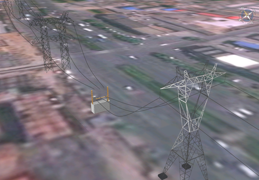
将中间的电缆杆塔更换为变压器后,电缆线重新连接
4. 执行模型属性的查询
平台不但支持向场景中添加模型实体,还支持查询模型的属性:
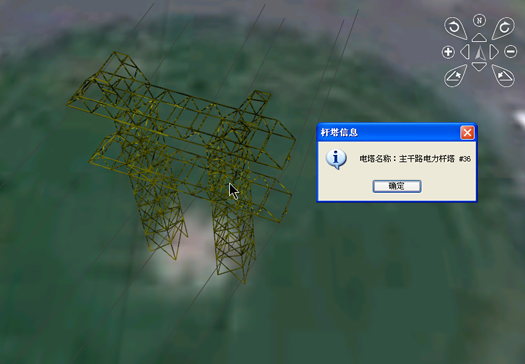
例如通过鼠标点击的方式查询某一杆塔的属性信息
5. 添加地下电缆槽
系统可以创建地下电缆槽坑道并且以透明的方式显示电缆槽坑道的内部结构。电缆槽坑道可以使用鼠标拖拽点击的方式在地图上进行添加。如创建一条简单的电缆槽坑道。其中电缆槽的深度宽度、支架的颜色、支架间的间距都是可以手动设置的。并且可以查询坑道内电力设备的属性。
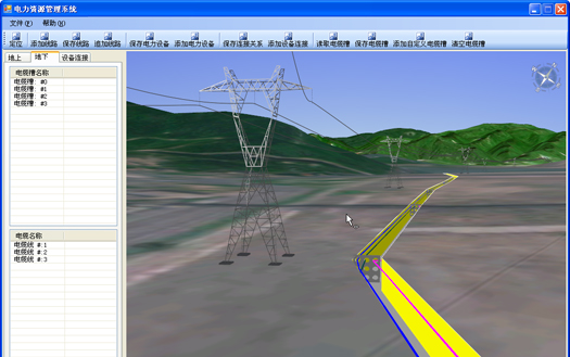
地下电缆槽坑道和地上电力杆塔全景
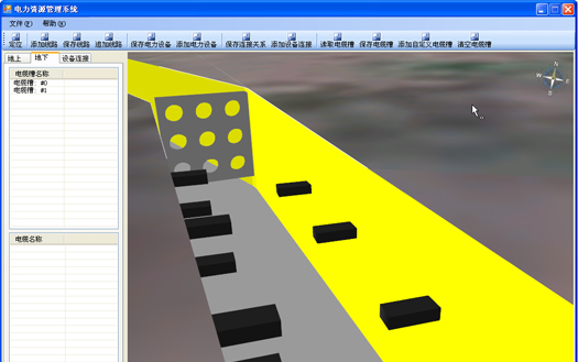
未添加电缆线时电缆槽坑道的内部结构,包括灰色的槽底,黄色的槽墙,黑色的电缆线支架,和灰色的带有管孔的电缆槽管块。
6. 支持动态添加地下电缆线
支持动态向电缆槽中添加电缆线,能够指定电缆线从水泥管块的那个管孔中穿越。另外可以设置电缆线的直径和颜色。
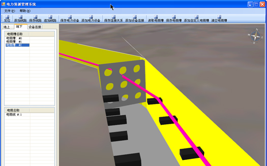
添加一条电缆线后的效果
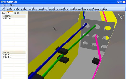
添加多条电缆线后的效果
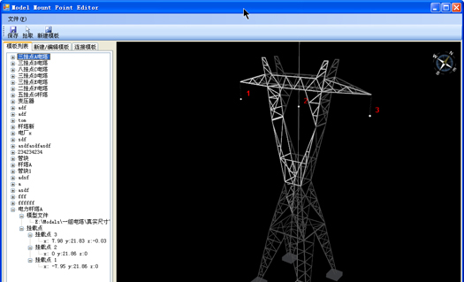
7. 高精度拾取模型节点
系统提供了像素级的模型选择能力,能够以感触式的方式选中模型,并可以对选中状态进行整体反馈。同时能够精确的拾取指定点的位置信息。
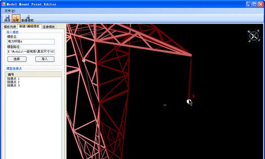
拾取电力杆塔上电缆线挂载点的具体位置
直角坐标系下模型的显示

